Introduction:
Looking for the ultimate overlanding adventure to add to your bucket list? Here’s a list of some adventures to consider. Each includes a description as well as links to sites with more information and GPS files. I also posted videos when possible.
Also check out:
Building A Ford Ranger For Overlanding
United States:
Alpine Loop (Colorado):
- Length: 60 Miles
- Season: July through September.
The Alpine Loop Scenic Byway, a network of four-wheel drive roads, is one of the most breathtakingly beautiful alpine drives in the world, connecting some of the most stunning scenery in the state of Colorado.
This rough, high-elevation route is not for the faint of heart; full of bumpy terrain with winding turns and steep drop-offs.
But for the adventurous offroad driver, the Loop’s views are more than worth it. If you’re looking for a breathtaking trip that will leave you with lasting Rocky Mountain memories, take the scenic route on the Alpine Loop.
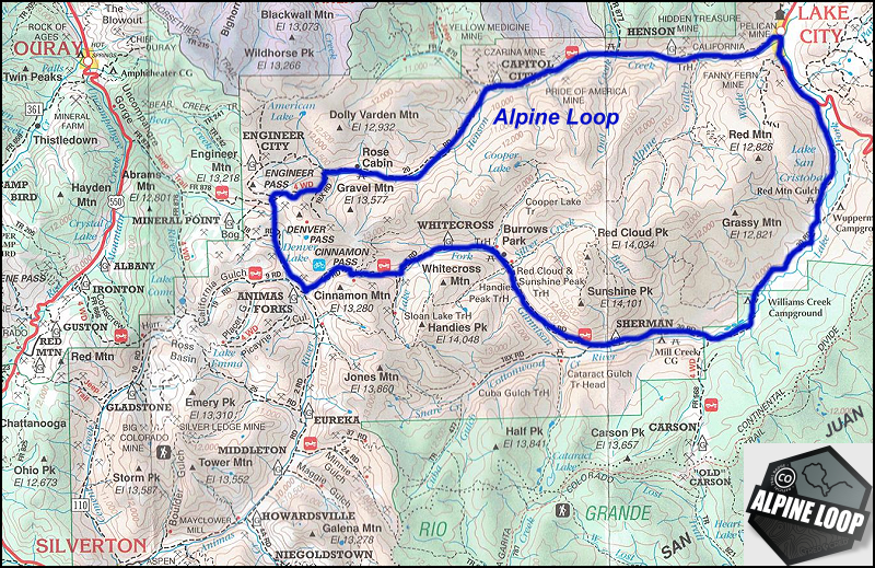
The Alpine Loop Scenic Byway, aka “the Alpine Loop” (or just “The Loop,” to locals,) is a 60+ mile network of old 4×4 mining roads connecting the southern Colorado mountain towns of Lake City, Silverton, and Ouray.
The Loop connects two high-elevation mountain passes, Cinnamon Pass and Engineer Pass, and only 4 miles of the entire 60+ mile route (a small section in Lake City) is paved. The Loop tops out at an elevation of 12,800 ft on Engineer Pass, with much of the road above tree line.
Over 100,000 people brave the Alpine Loop each summer, making it one of the most famous off-highway roads in the United States.
If you decide to brave the Alpine Loop, pack your vehicle like you’ll be camping overnight, even if you don’t plan to. In case of car trouble or bad weather, it may take several hours or even overnight before help can reach you.
Get more information and maps at:
The Ultimate Guide to Driving The Alpine Loop | Lake City – A Peak Experience
Alpine Loop — Colorado Department of Transportation (codot.gov)
Colorado Backcountry Discovery Route:
- Length: 691 Miles
- Best Time of Year: July through September. Depending on snowpack you might not make it through some high passes until sometime in July.
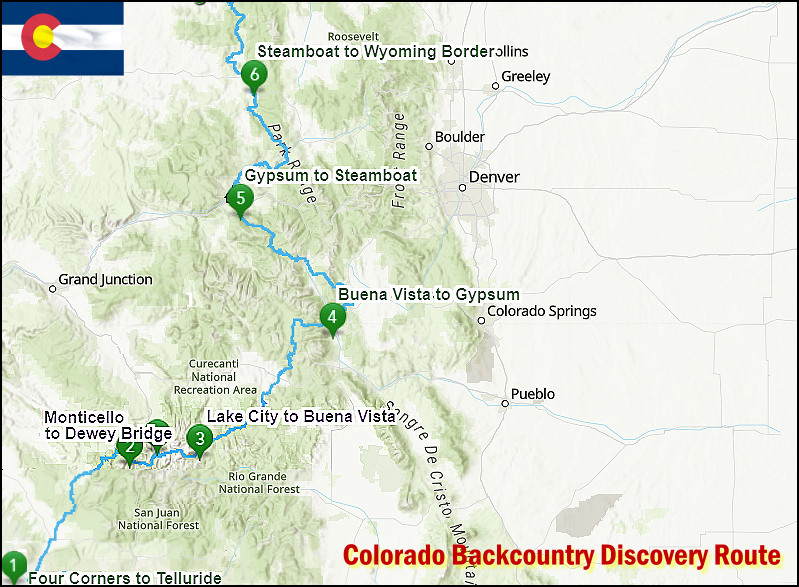
If getting high is your thing, Colorado offers some of the tallest mountains passable by motorcycle in the US. With several passes over 12,000 feet, there is no shortage of views on this route, just shortness of breath while taking in the sights in the thin air of Ophir, Corkscrew, Hurricane, California, Cinnamon, Cumberland, Cottonwood, Weston and Hagerman passes.
Beginning in the four corners location where, CO, AZ, NM and UT intersect, this 691-mile route winds its way north through the Rocky Mountains to the Wyoming border. The terrain includes dirt roads with rocks, sand and even a few water crossings to keep it exciting.
Get more information and maps at:
Colorado Backcountry Discovery Route (COBDR) Map & Information (ridebdr.com)
The Colorado Backcountry Discovery Route • The Adventure Portal
Colorado Backcountry Discovery Route (jerryblewis.com)
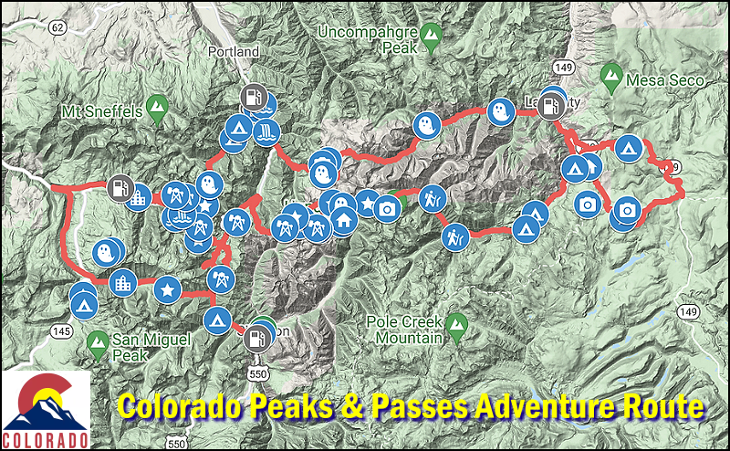
Colorado Peaks & Passes Discovery Route
- Length: 180 miles, 3-5 days
- Season: July – September. This route traverses some of the highest elevation roads in the United States. Check with local land managers to see if mountain passes are open.
The Alpine Loop is a popular trip in Colorado, but it’s only 60-miles long. This route 3-times the distance.
The Alpine Loop within the San Juan National Forest is one of the most sought after and iconic off-road routes in North America. Despite its name, the Alpine Loop isn’t much of a loop at all, but rather an extensive network of trails and roads separated by the iconic Rocky Mountains. Along the way you’ll be blessed with magnificent vistas, high alpine meadows and mountain likes, ghost towns, and the remains of old mining operations. We’ve pieced together what we think is the perfect route through the San Juans, with the goal of providing maximum payoff for the mileage.
Recommended Points of Interests:
- Ophir Pass, elev 11,789
- Black Bear Pass, elev 12,840
- Slumgullion Pass, elev 11,529
- Imogene Pass, elev 13,114
- Engineer Pass, elev 12,800
- Cinnamon Pass, elev 12,640
- California Pass, elev 12,960
- Hurricane Pass, elev 12,407
- Corkscrew Pass, elev 12,244
- Jarosa Mesa Pass
- American Basin
- Odom Point
- Animas Forks ghost town
- Capitol City ghost town
- Bridal Veil falls
For more details and map files visit:
Overland the San Juan Mtns | Guide, Maps + GPX (overlandtrailguides.com)
Continental Divide Trail:
This one is on my personal bucket list:
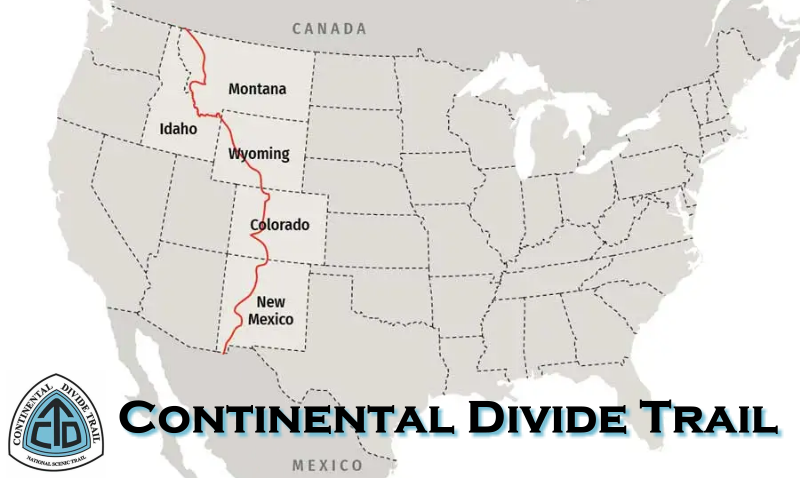
The Continental Divide is a drainage divide running along the Rocky Mountains. To the west of the divide, all the water flows into the Pacific Ocean and on the eastern side, all the water flows to the Gulf of Mexico and the Atlantic Ocean. The Great Continental Divide Adventure Route is a motorized route that follows closely along the Continental Divide National Scenic Hiking Trail. This scenic trail runs from the USA/Mexico border into Canada and covers 2,767 miles of spectacular remote wilderness. The Route covers 5 states: New Mexico, Colorado, Wyoming, Idaho and Montana and is a mostly a mix of smaller dirt roads and back county roads. This is considered a scenic adventure route, and most riders take two weeks to travel the length. Many riders camp along the route while others choose from many hotel options.
Get more information and maps at:
gpsKevin Adventure Rides – Great Continental Divide Motorcycle Ride
Border-to-Border Adventure: Jeeping Across the Continental Divide | Off-Road.com
Enchanted Rockies Trail:
- Location: Queen, New Mexico to Estes Park, Colorado
- Total Distance: 1,200 miles
- Estimated Time to Complete: 1-2 weeks
- Best Time to Travel: Late June to early October
Beginning in the tiny town of Queen, New Mexico (near Carlsbad) and snaking northward all the way to Estes Park, Colorado, the Enchanted Rockies Trail includes roughly 800 miles of off-pavement terrain. With relatively mild roadways, it’s a great stepping-stone to overlanding (at least in dry weather). While there’s spectacular scenery all along the route, we’re partial to the 140-mile stretch from Pecos to Angel Fire, which winds toward Santa Fe before hitting higher elevations (and the expansive views that go with it) in the Carson National Forest.
Get more information and maps at:
Enchanted Rockies Trail | Facebook
Enchanted Rockies Trail | Tacoma World
Kentucky Adventure Trail:
- Length: 1,000 Miles
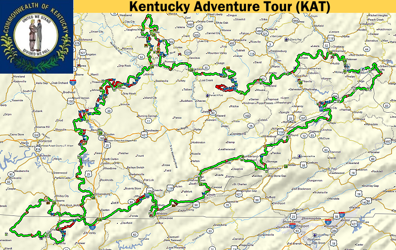
The Kentucky Adventure Tour (KAT) is a 1,000 mile loop (not counting the hard sections) around the hills and mountains of southeastern Kentucky. It is about 40% rural narrow twisty paved roads with the rest being gravel, dirt roads and trails. The KAT is divided up into 4-sections. and you can travel it in either direction and you can start at any location you like. Most adventurers tend to do portions of the route instead of the whole thing because of the distance.
To get the most up to date GPX files of the KAT, please join the Kentucky Adventure Trail Facebook Group to download the files.
Kentucky Adventure Tour (KAT) | Facebook
The Georgia Traverse:
- Length: 390 Miles
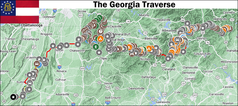
The Georgia Traverse is a collection of county, state and Forest Service roads that comprise a (mostly) off-pavement route across North Georgia. It is designed to be traveled east to west, beginning at Burrells Ford Road along the Georgia / South Carolina border. The Georgia Traverse visits North Carolina and Tennessee before ending at the Georgia / Alabama border. The total mileage of all paved and unpaved sections is 390 miles. I included a few alternate, off-pavement sections to explore along the Traverse. The total mileage includes the alternate sections, as shown in the map and represented in the download. However, roads not explicitly shown as part of the Traverse are not included in the mileage. Of the 390 total miles presented here, 226 miles are unpaved road surfaces consisting of gravel, dirt or both. Connecting the off-tarmac sections are 164 miles of pavement, with just over 40% of the paved miles found west of the Cohutta and Big Frog Wilderness Loop. Though I found limited opportunities for off-pavement connectivity in the western portion of the Traverse, I decided to include what I did find in an effort to offer a border to border travel experience across Georgia.
In addition to the 390 miles of tracks displayed on the map and offered in the download, I include over 500 waypoints that offer unique details (road names, possible campsites, hiking opportunities, water crossings, etc.) of what you will find along the Traverse. While much of the road data is available through a variety of sources, it is this collection of waypoints that set The Georgia Traverse apart from any other offering. As mentioned earlier, the Traverse is published with the intention of east-west travel. I attempted to include turn by turn directions when transiting between off-pavement and paved sections and these left/right directions are only accurate when traveling the Traverse east-west. Of course, there’s no reason why you cannot simply follow the tracks west-east and ignore the directions. In fact, I highly encourage people to view the Traverse as an opportunity to explore our beautiful state at their own pace, choosing portions to leisurely visit over many weekends rather than a single, long journey.
To get the latest GPX files and more information check out:
GEORGIA OVERLAND – Welcome to Georgia Overland
Idaho Backcounty Discovery Route:
- Length: 1,250 Miles
- Best Time of Year: July though October are ideal. Late June can be nice if the snow has melted from the high passes. Watch out for early snow and hunters if you are going in the fall.
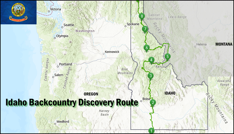
If you’ve ever wanted to ride endless twisty mountain roads, the Idaho BDR will throw corners at you for days on end. You also won’t get many digital interruptions because your cell phone won’t have reception on much of this route. It’s a true off- the-grid ride that is long enough, at 1,250 miles, that you might just use up an entire rear knobby tire.
Starting in the historic town of Jarbidge, NV the route crosses range lands and then heads into the Boise National Forest and treats riders with views of Andersen reservoir and epic alpine camping at Trinity lakes. Tiny towns and treasures like Burgdorf Hot Springs make this a bucket list ride for sure. You’ll travel where Lewis and Clark made history and experience the legendary Magruder Corridor and Lolo Motorway which skirt the roadless Selway-Bitteroot Wilderness. You will reach modest hints of civilization as you pass through Sandpoint, Bonners Ferry on your way to the Canadian Border.
Get more information and maps at:
Idaho Backcountry Discovery Route (IDBDR) Map & Information (ridebdr.com)
Idaho Backcountry Discovery Route IDBDR – July 2019 | Adventure Rider (advrider.com)
Mid-Atlantic Backways Adventure Trail:
- Length: 1,080 Miles
- States: Virginia, West Virginia, Maryland, and Pennsylvania
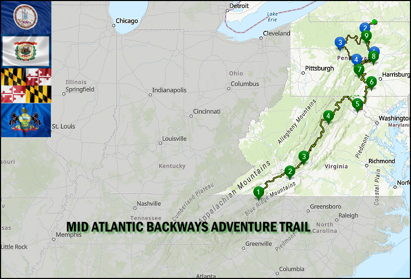
The Mid Atlantic BAT (MABAT) is a scenic ride for dual-sport and adventure motorcycles that uses dirt, gravel and paved roads to wind through remote parts of Virginia, West Virginia, Maryland, and Pennsylvania. Starting in Damascus Virginia, and ending in Lawrenceville, PA, this 1,080-mile route, primarily uses forest roads and rural country lanes, to lead riders through the Appalachian Mountains, majestic forests, bucolic farming landscapes, Amish country, and locations that played pivotal roles in early American history.
This ride is structured as a week-long adventure. Riders will spend each night in a different hotel along the route. Riders will be eating in restaurants and snacking on the trail. The ride includes a support truck to carry riders gear so that riders may enjoy a lightly loaded bike.
Mid-Atlantic Backways Adventure Trail – MABDR – gpskevin
This seems to be the same or very similar route:
Mid Atlantic Backcountry Discovery Route (MABDR) Map & Information (ridebdr.com)
Oregon Backcountry Discovery Route:
There are multiple adventure routes through Oregon.
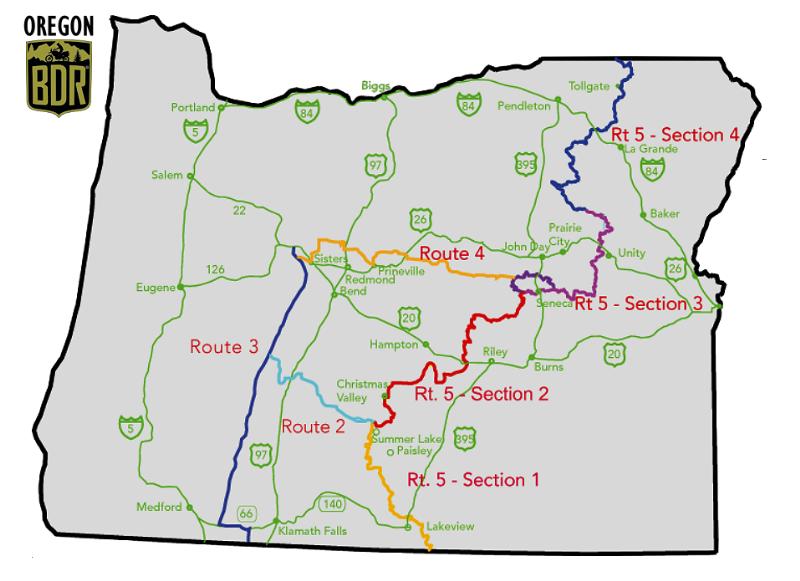
This Route travels from Nevada to Washington. This Oregon Backcountry Discovery Route (ORBDR) is a 670-mile, multi-day off-pavement adventure. Starting in the high deserts of the southeast and exploring north through ancient pine forests and into the rugged mountains of the Cascade Range, challenges include lava rocks, silt, sand, and arduous mountain roads. From sagebrush steppe and hot springs, to caverns and glaciated volcanoes, riders are guided into remote territories that reveal many of the state’s natural wonders, providing prime sightseeing and recreational opportunities. With stunning views throughout and terrain that is certain to test your riding skills and endurance, the ORBDR is one of the best ways to discover the backcountry of Oregon.
Oregon Backcountry Discovery Route (ORBDR) – Backcountry Discovery Routes (ridebdr.com)
Here you have 5 different routes with Route 5 having 4 sections which I believe is the route above.
The longest trail system in Oregon with over 1500 miles is waiting for you to explore and discover amazing country. Enjoy Oregon’s Crown Jewels of our highest snowcapped mountains, sand dunes, sage covered high desert to incredibly clear, blue water streams and breath-taking vistas. To really see Oregon’s beauty, one needs to forego the well-traveled areas and discover Oregon’s back country. Come along as we explore Oregon off the pavement. The Routes are as follows:
- Route 2 – Crescent Lake to Seneca
- Route 3 – Crown Jewels – Big Lake to California by Cascades
- Route 4 – Sisters to Seneca
- Route 5 – California to Washington – Has 4 Sections
- Route 6 – Cascades to Coast
Several loops are available by combining the different maps
Oregon Back Country Discovery Route (oohva.org)
Rimrocker Trail: (Colorado / Utah)
- Length: 160 Miles
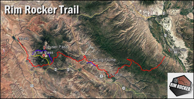
Spanning a distance of 160 miles, the Rimrocker Trail provides access through some of the west’s most stunning scenery. Visitors are immersed in natural beauty as the trail guides them through a landscape of redrock canyons, winding rivers, desert vistas and alpine forests. Whether you travel the whole route or just a portion, the experience will stay with you for a lifetime.
The Rimrocker Trail runs long stretches through remote areas. Large portions of the route are rough, narrow and steep. The route between Nucla and Moab is recommended for 4WD/High Clearance vehicles and OHVs only. When traveling on the Rimrocker, users should plan to be self-reliant and recognize that cell phone coverage is very limited.
On the ground marking of the Rimrocker Trail consists of fiberglass posts featuring a highly reflective sticker of the Rimrocker Trail logo and a directional arrow.Even though the Web Map Viewer shows a marker symbol for each mile point on the route, on the ground posts do not show the mileage and are not always located at a mile point. Instead, some signage is placed at locations where the trail intersects other roads in order to assist users with staying on the trail. Be aware that not all intersections are marked. It is highly recommended that Rimrocker Trail users adequately plan ahead before getting on the trail and familiarize themselves with the route.
Get more information and maps at:
Rimrocker Trailhead | Bureau of Land Management (blm.gov)
RimRocker Trail | Guide, Maps, GPX files (overlandtrailguides.com)
The Rimrocker Trail: 160 Miles of Dirt and Adventure From Montrose to Moab | DrivingLine
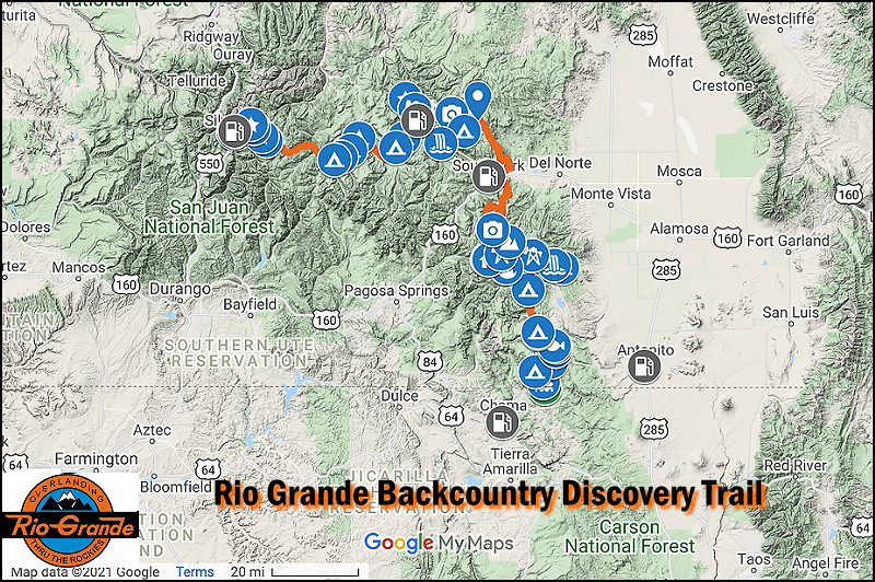
Rio Grande Backcountry Discovery Trail
- Length: 246 miles, 3-6 days
- Season: June – September. Check with the Rio Grande NF regarding the status of high elevation mountain passes.
Early pioneers came and miners arrived to this region of the San Juan Mountains in search of silver and gold. While the pioneers have come and gone, the Rio Grande National Forest retains its natural beauty and rich pioneer heritage. The Rio Grande offers a fantastic opportunity to get away from the crowds that flock to the Alpine Loop, without giving up any of the natural splendor that the Rockies are famous for.
Rio Grande Backcountry Discovery Trail (overlandtrailguides.com)
Trans America Trail:
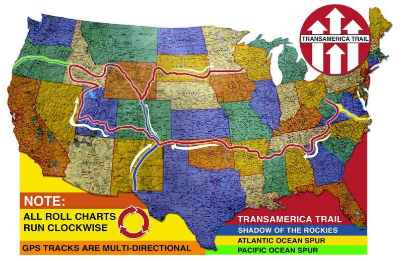
I have completed the Trans America Trail from its original starting point in Tennessee to the Pacific Ocean in Port Orford Oregon. You can see my journey at: Trans America Trail – The Ranger Station
The TransAmerica Trail is the cross-country adventure ride of a lifetime with mostly off-pavement travel. From scenic vistas and unique attractions to rough terrain and challenging conditions, the TAT presents every rider with the opportunity for an unforgettable journey and memories that will last a lifetime. Depending on the weather and location, riders may face challenges including mud, sand, snow, and rocks among others. As the trail is made up of dirt, gravel, forest, farm, and brief sections of paved roads, The TAT may be traversed using either a dual-sport motorcycle or a 4×4 vehicle.
The TAT is NOT a single-track ride with tight sections. It uses public roads and back country roads, both non-pavement and pavement. It does NOT cross any private land or locked gates. If you are using the official and original navigation, you will not have any trouble, unless something drastic has happened overnight that the TAT creator hasn’t been notified about.
TransAm Trail – with Sam Correro
Trans-Rockies Adventure Trail:
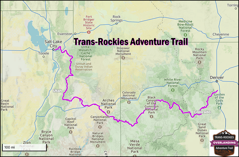
- Trip Length: 2 – 4 weeks, 935 miles (675 miles of dirt)
- Season: Late June/early July to October, but highly variable.
The Trans-Rockies Adventure Trail might just be the most epic overland track that traverses the heart of the Colorado Rockies and into the canyonlands of Utah, and finally through the Wasatch Mountains. Connecting Denver with Salt Lake City, the 935 mile track features nearly 700 miles of dirt through some of the most iconic mountain tracks and passes through the Rockies. Along the way, expect to be blown away with spectacular alpine views, majestic peaks, alpine lakes and meadows, red rock canyons, and a series of high elevation jeep tracks and mountain passes.
Get more information and maps at:
Trans-Rockies Adventure Trail (overlandtrailguides.com)
United States – Alaska
James Dalton Highway:
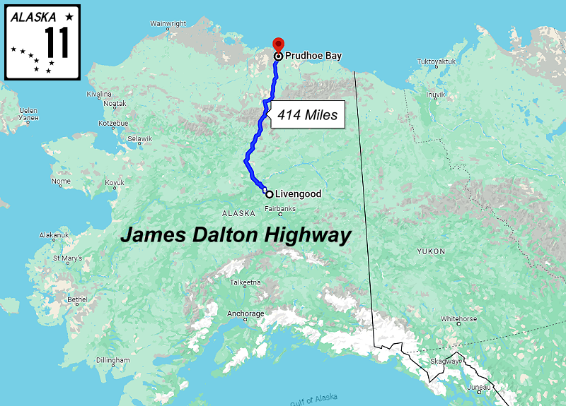
Location: Livengood, AK to Deadhorse, Alaska
Distance: 414 miles
Recommended Trip Duration: 3-5+ days
When to Go: June to mid-July
The mostly gravel road in Northern Alaska stretches 414-miles from Livengood to Deadhorse. It was originally built as a service road for the Trans-Alaska Pipeline and is still considered one of the most dangerous roads in the U.S., mainly because of the lack of services and cell phone reception along the entire route. The payoff for braving the Dalton? You get to see some of the most spectacular wilderness in the country, traversing the Brooks Range and crossing the Yukon River on the way to the Arctic Ocean.
The Dalton Highway is one of the most isolated stretches of road in the United States, with only three towns along its 414-mile path linking Fairbanks Alaska to the oil fields of Prudhoe Bay along the Trans-Alaska Pipeline.
While it largely consists of two-lane gravel road, it’s the isolation, steep grades, often poor visibility, and limited availability of resources that makes it an incredible overland trail.
While 4WD is not required, due to the limited number of refueling stations and poor road conditions it’s highly recommended to carry extra fuel, at least one full-size spare tire, and a tire repair kit. Cell service is non-existent throughout the route, so a satellite communication device should be taken and weather conditions should be monitored closely leading up to a trip along this treacherous route.
Get more information and maps at:
Guide to the Dalton Highway | Livengood to Deadhorse | ALASKA.ORG
Canada:
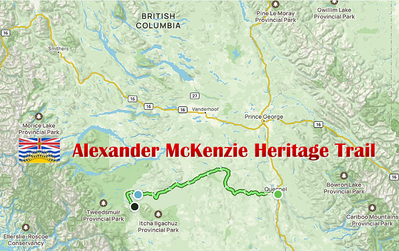
Alexander Mackenzie Heritage Trail (British Columbia):
In recent years, the Alexander Mackenzie Heritage Trail has become a rite of passage for serious overlanders in British Columbia. Those willing to accept the challenge will have their vehicles and mental fortitude tested and pushed to the brink. The Alexander Mackenzie is not for the faint of heart!
Only experienced overlanders should attempt this trail. Gear on hand should include winch and traction boards, chainsaws, and at least an extra tank of fuel. The Mackenzie is notorious for having a plethora of deadfall (especially earlier in the season), numerous bogs and muddy sections, and river crossings that can exceed 30″ in depth. You’ll likely need to use your recovery gear on numerous occasions throughout the trail, and because of this, traveling in a group with other vehicles is recommended. Bear spray (you’re in grizzly country) and insect repellant is recommended. If you’re not familiar with the Alexander Mackenzie Heritage Trail, here is a video that you should watch: HARDEST Overland Trail In North America (We Almost Died)
You’ll need the GPX file from ONX OFFROAD:
You can also get more information and map files from:
Alexander Mackenzie Heritage Trail (overlandtrailguides.com)
The Dempster Highway (Yukon / Northwest Territory):
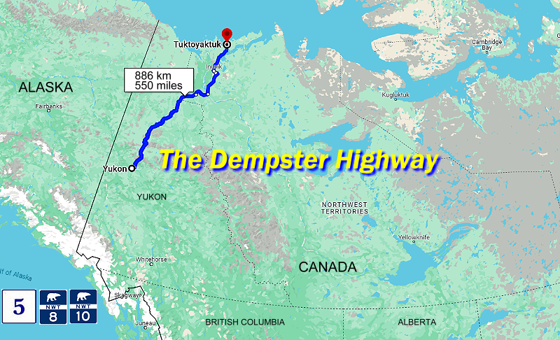
- Length: 886 km/550 Miles
The Dempster Highway was completed in 1979 and is a well-maintained gravel and crushed stone road which extends 742 km/461 miles to Inuvik (Place of Man) an Inuit village 325 km above the Arctic Circle in the Northwest Territories. The Dempster Highway starts 40 km/25 miles east of Dawson City and 496 km/308 miles north of Whitehorse. It is 782 km from Dawson City to Inuvik.
This wilderness route spans remote regions of the Yukon cutting through two rugged mountain ranges, the Ogilvie and Richardson Mountains. Travellers will encounter miles of stunted spruce and alder “forests” (8′-12′ tall) in the Eagle Plains region, and elevated reaches of tundra, before dropping to the Mackenzie River and its flat aspen covered delta.
On the Dempster Highway gas stations are limited. Gas, diesel fuel and repairs are available at Eagle Plains 365.7 km/227 miles, Ft. McPherson 555 km/345 miles, and at Inuvik. Appropriate preparation is essential. Camping on the Dempster Highway is possible at a few private campgrounds and provincial parks.
Following Highway 10 north from Inuvik for 138 km/86 miles will take you to Tuktoyaktuk and the Arctic Ocean for a total of 886 km/550 miles.
Get more information and maps at:
Dempster Highway to the Arctic Ocean – Spectacular NWT
Dempster Highway mile by mile description (bellsalaska.com)
